
The Lie of the Land
Sunday, 2 August 2026
Every outlook this site writes turns out, sooner or later, to be about the same four neighbours: the Alps, the Po plain, the Apennines, and the Adriatic. Bologna sits where the last three meet — on the final metres of flat ground before the mountains, at the southern rim of the plain, an hour from the sea. Once you can picture that arrangement, most of the recurring plot lines in the forecasts explain themselves.
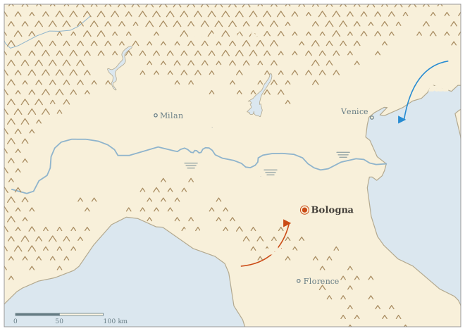
The plain. The Pianura Padana is a bowl — walled by the Alps on one side and the Apennines on the other, open only toward the Adriatic. Air that gets in has a hard time leaving. In winter that means fog and low stratus that can sit for days while the hills above are in sunshine; in summer it means humidity with nowhere to go, which is why the dew point gets more column inches here than temperature. It is also why the daily blurbs track PM2.5: the same stagnation that pools fog pools everything else.
The mountains. The Apennines start at the edge of town and climb to roughly 1,700–2,000 m within forty kilometres. Southwesterly flow has to cross them, drops its rain on the Tuscan side, and arrives in Bologna as the garbino — a föhn wind, suddenly warm, bone-dry, and gusty, good for a few startling thermometer spikes a year. The same ridge is where summer afternoon storms fire first, before rolling northeast onto the plain — the reason so many outlooks hedge with “initiating over the ridge.”
The seas. Cold air from the northeast — the bora — comes down the Adriatic and up the open end of the bowl, and because it travels over water it arrives moist: the classic Bologna snow setup is exactly this, cold Adriatic air undercutting milder flow. The Ligurian side matters differently: lows spinning up in the Gulf of Genoa are the plain’s most reliable rain-makers, close enough to matter and small enough that the models argue about them all week.
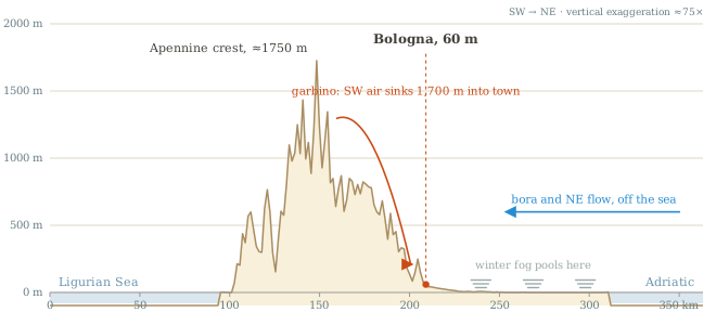
The cross-section is the whole climate in miniature: anything arriving from the southwest has just fallen 1,700 m and behaves like it; anything arriving from the northeast has had a hundred kilometres of flat, wet plain to pick up moisture. Which side of that section a pattern favours is, most weeks, the first question the outlook has to answer.